
742 flights, one Icelandic field, no pilot on site
Case study — remotely supervised BVLOS atmospheric profiling. Iceland field campaign, 2025.
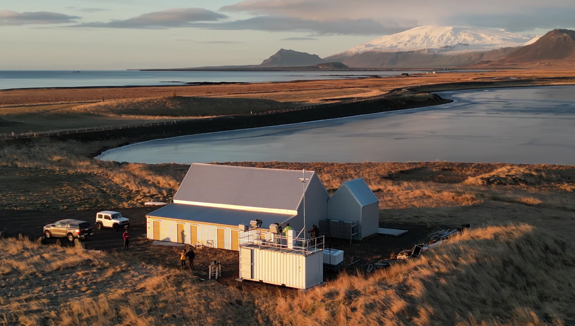
Menapia’s Icelandic test facility: a container workshop, drone docks and atmospheric observatory on the Snæfellsnes Peninsula, with Snæfellsjökull in the background.
At Menapia’s Icelandic test facility, a new drone-in-a-box system ran routine vertical profile sorties: launch, climb, recover, recharge and repeat.
Across the campaign it completed 742 flights, with more than half reaching above the boundary-layer top (3.2 km AGL max). The system was remotely supervised, with no pilot required on site for these routine operations.
Each sortie produced an in-situ vertical profile of the lower atmosphere: temperature, humidity, pressure and wind sampled from the surface upward. The point was not a single impressive flight. It was repeatable, high-cadence atmospheric profiling from a remote site, using an automated dock, a field-hardened aircraft and an operating model built around BVLOS permissions, remote supervision and controlled aviation risk.
Why automated profiling matters
Atmospheric scientists and operational meteorologists already have good tools. Radiosondes remain the reference for full-depth upper-air soundings. Towers and surface stations give stable long-term measurements near the ground. Lidars, radars and radiometers provide continuous remote sensing. Aircraft and dropsondes can sample targeted regions in detail.
The limitation is not measurement quality. It is observing density: how often you can profile, how many places you can cover, and how quickly you can respond when the atmosphere changes.
The constraint is cost and logistics. Conventional profiling is labour-intensive and consumable-heavy, so profiles are usually limited in time, location or frequency. A docked UAS changes the economics. Once deployed, each additional profile is a reusable sortie: energy, battery wear, data handling and remote supervision — not a fresh balloon launch and field procedure.
That reduction in marginal cost enables the real step change: more profiles per day, longer campaigns, more observing sites and event-triggered sampling when the atmosphere is evolving fastest. For the same budget, you can move from isolated snapshots to dense spatio-temporal coverage.
That is what Menapia is building through its wider MetSprite programme: reusable UAS infrastructure for routine, high-cadence, in-situ atmospheric profiling.
What we were really testing
This campaign was a long-term harsh-environment shakedown of a new drone-and-dock system integrated into Menapia’s wider UAS fleet.
The dock had to launch, recover, protect and recharge the aircraft through repeated operating cycles. The aircraft had to operate in wind, cold, precipitation and fast-changing weather. The remote operating workflow had to support routine supervision rather than hands-on piloting.
We were also testing a new generation of Menapia’s core onboard meteorological sensing suite: lower SWaP-C while retaining the measurement performance needed for research-grade atmospheric profiling. Lower SWaP-C matters because it turns the met package from a bespoke payload into a fleet-scalable core system: easier to deploy, easier to maintain (Quality assurance and re-calibration), and suitable for routine use across multiple aircraft and sites.
The output was not just flight hours. It was operational evidence: dock cycles, charging behaviour, recovery performance, weather-limit decisions, data continuity, sensor performance and maintainability in a hard field environment.
What it Shows
742 remotely supervised profile sorties are a useful maturity marker for one of our new UAS systems.
They show that Menapia’s growing fleet of automated profiling systems can operate as field infrastructure, not just as campaign demonstrators. The aircraft can repeatedly collect vertically resolved atmospheric data. The dock can support routine operation. The operating model can support BVLOS profiling without a pilot standing in the field.
That is the direction of travel for atmospheric observations: reusable systems, lower marginal cost, higher cadence and deployment in places where conventional observing is too sparse, too expensive or too labour-intensive.

Our Iceland site
Menapia has operated from its Snæfellsnes test site since May 2024.
The site gives us something hard to find in the UK: low population density, low background air traffic, open operating space and weather that stresses UAS technology properly. Wind, cold, icing risk, sea air, precipitation and rapid weather transitions expose weaknesses quickly.
The meteorology is also useful in its own right. The site sits in a complex coastal, orographic and high-latitude environment, with Atlantic weather systems, volcanic terrain and Snæfellsjökull all influencing local atmospheric structure.
For customers working towards Greenland, Iceland is also a practical stepping stone. It is far easier to move people and equipment to Snæfellsnes than to the Greenland Ice Sheet, but an Icelandic winter can reproduce many of the operating stresses relevant to Greenland summer field campaigns: cold, wind, precipitation, icing risk, remote power, remote communications and limited on-site intervention.
That combination makes the site valuable for Menapia and for our partners: logistically accessible, operationally safe, meteorologically complex and hard enough to matter.
Video filmed shortly after deploying, as the GAMB2LE team arrived to install their lidar alongside our drones:
What we learned here is already shaping the next generation of the platform — and the next, colder places we'll fly it with Team GAMB2LE.