
Flying off the back of a ship: STRINQS in the tropical Atlantic
Case study — simultaneous, coordinated shipborne atmospheric profiling for TU Delft, aboard R/V Meteor in the tropical Atlantic, 2024.
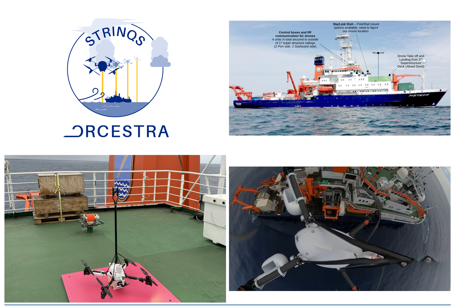
The STRINQS campaign: R/V Meteor, the drone operating layout on deck, an aerial view from a MetSprite in flight above the ship, and a MetSprite Mk2 on its landing mat. Menapia / STRINQS, August 2024
In the summer of 2024, four Menapia quadcopters went to sea. They flew from the deck of a German research vessel in the middle of the tropical Atlantic, climbing through the lowest kilometre of the atmosphere to measure how the ocean and the air above it exchange heat, moisture and momentum. As far as we know, no one had flown coordinated, simultaneous vertical profiles like this — several drones aloft at once — from a moving ship in the open ocean before.
The campaign was STRINQS, run for Professor Geet George's group at TU Delft as part of ORCESTRA — a 2024 multi-platform consortium studying convection over the tropical Atlantic, specifically to improve models of the intertropical convergence zone (the famous doldrums/horse latitudes). The aircraft embarked on the research vessel Meteor from São Vicente in Cape Verde and worked the mid-Atlantic boundary layer through August.
Why a drone, and why this is hard
On a previous campaign dropsondes were used to capture theromdynamic vertical profile measurements, they were dropped out of a research jet that flew an orbit around the ship. This year Geet wanted to use Menapia’s MetSprite weather drones as more precise and lower cost alternative.
Taking our land-based profiling drone to sea meant solving several problems at once:
A salt-proof power train. Continuous salt aerosol and fast-charge turnarounds in humid air are brutal on connectors, batteries and motor controllers. We re-engineered the power and propulsion stack — including a cell-chemistry change that bought far more current headroom — so a drone could fly profile after profile and recharge in 20–30 minutes between them.
Landing on a moving deck. An autopilot expects its home point to stay put. Ours doesn't, at sea. We taught the ground station to feed the ship's live position into the aircraft so its landing zone tracks the vessel as it moves, and re-tuned how the drone recognises that it has actually touched down on a deck that is itself rising and falling on the swell.
Three drones, one formation. The science called for a three-aircraft hexagon at 300, 600 and 900 metres, a minute apart, all flying the same relative geometry around a ship that keeps moving. We flew it.
A life jacket. If a drone goes in the water, you want it back. We built a flotation module to keep a ditched airframe at the surface long enough to recover it — and learned a few things the hard way about how to deploy one reliably.
One airframe, three instruments. Each drone carried our own temperature/humidity/pressure stack, and a sonic anemometer for 3D wind — all on a shared clock, so every measurement lines up in altitude and time.
Because the ground station had a satellite link, our engineers back in the UK could watch what was happening on deck in the mid-Atlantic and help troubleshoot in near real time — useful when the nearest spare part is a thousand miles away.
What we got
Across the campaign the fleet flew 45 profiles, around ten flight hours in total — including the first three-drone coordinated hexagon flown from a moving research vessel. One of the nicer datasets caught a squall rolling through: pre-storm winds of half a metre per second building to eight or nine over twenty-five minutes, the humidity jumping and the temperature dropping three degrees as the boundary layer reorganised itself. That is exactly the kind of fast, fine-grained structure this approach exists to capture.
The ocean took its toll, as it does — and every fault we hit on deck became a design note for the next generation of the aircraft. That feedback loop, from a hard real-world deployment straight back into the airframe, is the whole point of building drones we can open up and improve.
Working with TU Delft
STRINQS worked as a true partnership: TU Delft brought the science and the campaign; we brought the aircraft, the integration and the flight operations — and trained their team to fly the system themselves, so the capability stayed with them after we sailed home. We're continuing to work with Geet's group on what comes next.
STRINQS was conducted with Prof. Geet George (TU Delft) as part of the ORCESTRA 2024 campaign, aboard R/V Meteor.